Climbing in Rocklands this Season? Here’s What You Need to Know After the Cederberg Fire
The Cederberg, a protected wilderness area managed by CapeNature and home to some of the most iconic climbing and bouldering routes in South Africa, was recently impacted by a wildfire that began on 7 March 2025. The fire ignited near Krakadouw Peak and burned for 13 days, before being fully contained on 20 March. In total, it scorched 20,834 hectares, spanning 97 kilometers of fire line, and included damage to the Rocklands “Bouldering Area”— a popular climbing zone.
As a result of the fire, several popular climbing sectors and access routes have been damaged or are temporarily inaccessible. Beyond the loss of infrastructure, the blaze also impacted large areas of fynbos vegetation—including unique and irreplaceable renosterveld and succulent karoo found in the Cape Floral Kingdom—as well as critical habitats for local wildlife. Therefore, selected hiking trails and surrounding areas have been closed to prioritise public safety and allow the landscape time to recover.
The fire has also had a significant impact on the local eco-tourism economy, which depends heavily on seasonal visitors drawn to Rocklands for its exceptional bouldering and natural landscapes. With access restricted and timelines for reopening still uncertain, many local businesses and tourism operators are experiencing financial strain.
In response, CapeNature, in collaboration with the Rocklands Association for Development (RAD) and other partners, has put forward a comprehensive Season Readiness Plan. This initiative aims to support the safe, phased, and ecologically responsible reopening of affected bouldering areas, whilst also helping to revive the local economy through carefully managed access.
This coordinated effort not only tackles the immediate post-fire challenges but also lays the groundwork for long-term stewardship of the area. By working together, CapeNature and its partners are committed to ensuring that Rocklands remains both a world-class climbing destination and a protected natural heritage site for generations to come.
Open Climbing Areas (Unaffected by the Fire)
The following climbing sectors remain open and fully accessible, as they were not impacted by the recent fire. Climbers are welcome to enjoy these areas with a valid permit and in accordance with CapeNature regulations.
Open areas include:
- The Rhino
- French Side
- Campground
- Champsite
- Dogtown
- Off the Road
- Leanne
- The Section
- The Place to Be
- Champside
- Wild West Wall
- Biscuit Buttress
These locations continue to reflect Rocklands' unique beauty and world-class climbing potential. We encourage all visitors to enjoy them responsibly and sustainably, helping to protect the environment and support the area's long-term recovery.
Closed Areas (Fire-Damaged and Under Recovery)
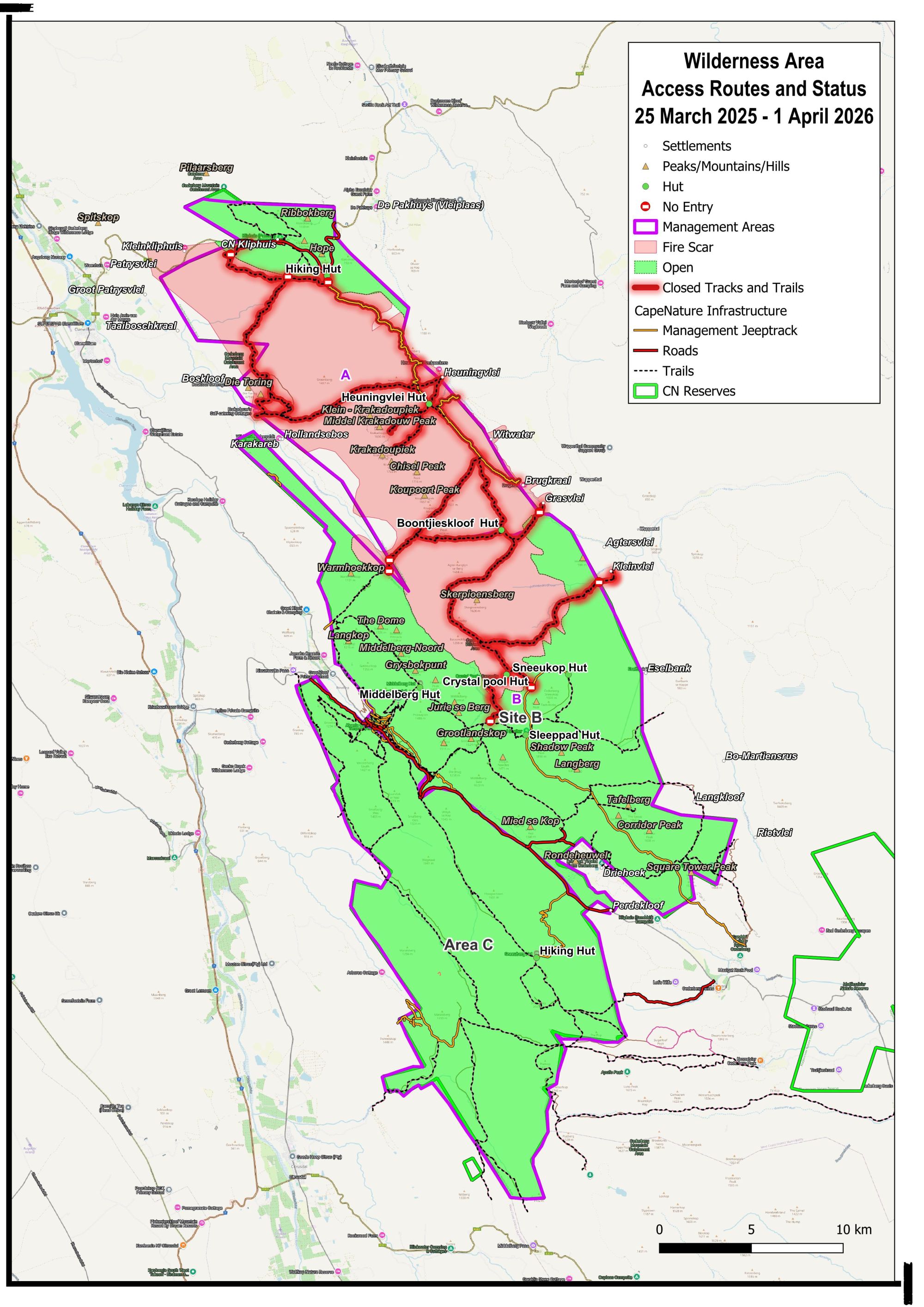
Several popular climbing areas were directly affected by the fire and are now closed for a minimum of 12 months to allow for environmental rehabilitation. Entering these areas is strictly prohibited.
Closed climbing areas include:
- Cedar Spine Gully
- Last Day in Paradise
- Narnia
- Saddle
- Otherside
- The Island
In addition, all hiking trails in the Rocklands Bouldering Area, Area A remain closed until further notice, as trail infrastructure is being reassessed and repaired where possible. Please consult the official closure map before planning your visit.
Temporarily Open Areas (Access Under Strict Conditions)
A few sites within the fire-affected zone have been granted temporary access under very specific conditions. These areas are being closely monitored, and any non-compliance will result in their immediate closure.
Temporarily accessible areas include:
- Roadside
- Riverside
- Roadcrew
- Fortress
- Bastille / Fortress Sport Crag
- Roadside Sport Climbing
- Gallery
Access to these areas is permitted only via marked and signposted routes, and visitors must adhere to all guidelines to prevent further environmental degradation.
Strict Access Requirements
To ensure both climber safety and environmental recovery, the following conditions MUST be followed:
- Permit Required: A valid bouldering permit is mandatory
- Time Restrictions: Access only between 10:00 am and 16:00 pm (exit the area by 18:00 pm). To prevent climbers and visitors from getting lost or straying off the trail by taking shortcuts through sensitive recovery areas, we ask everyone to please adhere to the designated access times.
- Mandatory Check-In: All visitors must sign in at the Pakhuis Pass Control Booth
- Daily Capacity Limit: Maximum of 100 visitors per day
- Stay on Path: Use only marked trails; remain within 2 meters of bouldering zones
- Minimise Impact: Avoid walking on or disturbing any burnt vegetation or soil
- Wildlife Protection: Do not approach or disturb animals—many are displaced and vulnerable
- Zero Tolerance Policies:
- No littering
- No fires, smoking, or gas cookers
- No alcohol or substance use
- No dogs or domestic animals
- No off-trail exploration
Please note: These areas are under active surveillance, including monitoring by rangers, volunteers, drones, and cameras.
To protect climbers and visitors from getting lost or unintentionally straying off marked trails—especially through fragile recovery areas- a strict closing time is enforced before sunset. Navigating after dark significantly increases the risk of losing the path, which often leads people to take shortcuts through sensitive ecological zones that are in the process of natural restoration. These shortcuts can cause lasting damage to recovering vegetation and habitats.
The opening and closing times are carefully selected to ensure climbers have enough time to safely complete their climbs without disturbing the wildlife during early morning, evening or night activities which are critical to their survival. It is also important for climbers to have daylight hours to see the routes and impacted areas clearly and to reduce light pollution in this sensitive area.
By adhering to the closing time, visitors help preserve the integrity of the landscape and maintain safety for all.
Volunteer and Staff Commitment
Our ability to protect Rocklands’ natural environment relies heavily on the commitment of our dedicated staff, volunteers, and local landowners who share a passion for its preservation. They play a crucial role in managing access points and ensuring responsible use of the area. We sincerely appreciate everyone’s cooperation in respecting the access hours.
A Call to the Climbing Community
The recovery of Rocklands is not just the responsibility of landowners—it’s a collective effort. As climbers and outdoor enthusiasts, we have a duty to protect the spaces we cherish. By respecting closures and following all guidelines, you’re actively contributing to the long-term health of this incredible landscape.
Non-compliance has immediate consequences, including the re-closure of temporarily open areas and restricted access for all visitors.
Thank You for Your Support
CapeNature and its bouldering partners extend sincere gratitude to the climbing community for your continued support, patience, and cooperation during this time. Together, we can protect what makes Rocklands extraordinary—not just for climbers today, but for future generations.
Please check for updates regularly and refer to the official map and CapeNature website before your next visit.
For questions or concerns about access, permits, or closures, please contact CapeNature directly or consult your local climbing organisation.
Related News

CapeNature maintains clean audit record and expands the Western Cape’s Protected Areas
CapeNature's 2025/26 Annual Report shows the Entity added more than 44 000 hectares to the Western Cape conservation estate over the year. The additions extend protection across mountain catchments that feed the province's water supply, guarding them against the invasive plant growth and wildfire risk that threaten water security. Ultimately the protected areas expansion improves our ability to conserve the rich and unique Western Cape biodiversity.

WESSA recognises 62 Blue Flags and 19 Green Coast sites as South Africa marks 25 years of coastal stewardship
South Africa’s Blue Flag and Green Coast programmes are entering their next chapter with a renewed focus on environmental stewardship, inclusion, community participation and long-term coastal resilience, as WESSA, the Wildlife and Environment Society of South Africa, celebrates 25 years of Blue Flag in South Africa and its own centenary.

CapeNature visitors invited to support communities through new donation scheme
A visit to a CapeNature nature reserve can help a neighbour in need. From 5 October 2026, guests at three participating nature reserves can bring gently used clothing, blankets and other essential items for local non-profit organisations. The first phase of the donation scheme will run at Grootvadersbosch Nature Reserve near Heidelberg, Kogelberg Nature Reserve near Kleinmond, and Cederberg Wilderness Nature Reserve near Clanwilliam.

Radio network upgrade to strengthen emergency communication in Hangklip area
CapeNature and Overstrand Municipality will install a small radio repeater station near Hangklip Peak as part of an upgrade to the region’s radio communication network. The repeater will strengthen the communication networks used by both parties and improve coverage across the Overstrand municipal area, Kogelberg Nature Reserve, Betty’s Bay Marine Protected Area and parts of the City of Cape Town. Reliable radio communication is essential for the daily operations of

State of Conservation Report 2026 tracks progress and pressures facing Western Cape biodiversity
The Western Cape’s biodiversity is facing mounting pressure, with a sharp increase in the area affected by fires and more ecosystems and species classified as threatened, according to the Western Cape State of Conservation Report 2026. The report records 107 fires that burned 215 936 hectares during the 2025/26 reporting period – almost three times the 75 174 hectares burned by 97 fires in the previous reporting period.

El Niño raises fire risk as Western Cape prepares for a challenging fire season
The Western Cape is preparing for a potentially challenging wildfire season, with the developing El Niño weather pattern expected to contribute to hotter and drier conditions and an increased risk of wildfires across the province. The South African Weather Service has warned of below-normal rainfall associated with the expected strong El Niño during the coming summer season. While El Niño does not automatically mean that every part of the province will experience drought